New Zealand

When I decided to retire
from my winter work, I decided that New Zealand was the first place I wanted to go. Most of the trip was focused on hiking, working my way from south to north with stops in the larger cities. In the back of my mind I had an Appalachian Trail type trip in mind. It didn't work out that way but it was still a wonderful experience and a spectacular trip.

Getting Started

I arrived in New Zealand with an Appalachian Trail type hike in mind walking the length of the country from south to north. And although it didn't entirely play out that way, getting acclimated in a the small town of Invercargill was much easier than it would have been in Auckland.

I checked into a hotel recommended by Lonely Planet and spent a day or two getting rested from the flight, checking out the town and sorting through all the Great Walks reservations, bus passes, hut passes and phone cards.

The ferry terminal for Stewart Island is in Bluff and what I didn't realize at first was that in New Zealand, especially southern New Zealand, the buses come to you. There I was all ready to take my pack halfway across town to the bus station wondering why everyone was looking at me funny when all I needed to do was stay put. You tell the bus where you're staying when you make your reservation and they do the rest.

The scenery on the Rakiura Track doesn't amount to much but New Zealanders love Stewart Island because it's so unspoiled. I loved it because it was a gentle warm-up hike, had unbelievable tropical plantlife and because it was a nice low stress introduction to dealing with the Dept of Conservation (DOC). I returned to Invercargill before heading off to Tuatapere to do the Hump Track.

The Hump Track was a much more strenuous trip than the Rakiura especially getting up to the ridge on the first day. It starts with a walk along the beach that alternates between dirt tracks and beach walking.Then it heads into the woods, remains level for a while and then climbs steeply to the ridge. It was foggy the afternoon I got to the ridge so I didn't appreciate the scenery until the next day but the second day was a gem. A magnificent view down to Te Waewae Bay and the ocean and a wonderful ridge walk before heading back down off the ridge and back to the trailhead.

Fjordland National Park

For me this is the heart of New Zealand.
Stewart Island may represent the natural unspoiled New Zealand to the European kiwis. Auckland might do it for the jet-set. Tongariro and the other sacred peaks may do it for the Maori but Fjordland's majestic mountains and dramatic coast are the places I think of when I think of New Zealand.

Much of it has been left untouched and the tracks cover only a small area, enough to touch the highlights but leave much of it alone. One has to resist the urge to conquer and explore in favor of taking it in and leaving the rest. This is what draws legions of hikers from all over the world. The entire southwest corner of the island is uninhabited and only accessible by boat for hundreds of miles. So even if you wanted to try and hike across it, the distances between resupply would be daunting. One just has to take it on its own terms even if it means not seeing everything that's out there.

The Kepler Track was my first Great Walk in the park. It's one of only two ridgeline hikes I did the whole trip and even then it's more of a jagged jumble than a ridge but what a view. The track starts by Lake Te Anau and winds along the beach for some time. Then it climbs steeply but steadily to the treeline and the Luxmore Hut. Once I broke out of the trees and looked ahead at the mountains and back down to the lake, I knew I was in for something special. Hump was a hint. Kepler was the full story.
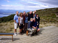
The hut itself had a spectacular view. Just as I was getting settled in a helicopter landed on a small wooden platform and a group of formed a wedding party and held a ceremony on the front porch. Champagne for everyone, friend and stranger alike. I had to admit it had style.

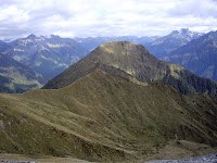
The second day was all about the ridge walk. With Lake Te Anau below and snow capped mountains going on into the distance, the Kepler track winds its way in, over and around the mountains before dropping back down to the Iris Burn Hut Signs along the trail indicate hours rather than distance and these were hours I was happy to drag my feet and enjoy the hike.

The Mavora Track is not part of the park and was much rougher. It's nice and smooth past Mavora Lake to the Boundary Hut where I had lunch. But after that it was a grassy, wet, difficult walk along the valley to the Taipo hut where I spent the night all the way to where it met the Greenstone Track. The Greenstone Track is another valley walk above the Greenstone River that was more an exercise in getting from here to there while I was still in my south-to-north thru-hike phase. It did get me to Milford Sound but since I had to go all the way back to Te Anau to get my hut tickets for the next track it was hardly the smoothest part of the journey. Still following the waratahs or painted metal poles was a good pathfinding challenge and it was my first introduction to walking along the river valleys of New Zealand.

Mt Aspiring National Park


Mt Aspiring National Park continues north from Fjordland heading inland toward even higher mountains. Most of the tracks involved climbing over a passes many of which were highlights in and of themselves. I was warmed up and into a good routine at this point so things were really starting to roll. The Routeburn and Rees/Dart Tracks in particular were fabulous. Bad weather and fatigue messed things up on the Wilkins/Young Track whose only fault was not being quite as spectacular as the others.

The Routeburn Track is kind of its own animal. It goes along a ridge but not on top. It follows a river but not in a valley. It has falls and lakes where you don't expect them. And it's spectacular in ways that other tracks aren't.
After the hike in to MacKenzie Lake it follows a spectacular route up to and along the Serpentine Ridge and over the Harris Saddle with magnificent views of even higher mountains across the Hollyford Valley. From the Harris Saddle a side trail ascends Conical Hill which gives a 360' view of it all. The descent follows the Route Burn (burn is Scottish for river) from Harris Lake down to a flat valley before descending further to the pick-up point.

Rees/Dart Track follows a pretty conventional route, valley-pass-valley with a twist. It's not a tramp on the Rees-Dart without a side trip to the Dart Glacier. AT hikers will seldom stray a foot from the trail without food being involved but at this point I was over my south-to-north thru-hiking plan and willing to accept things on their own terms.
The side trip was a chance to see the 'river of ice' from all sides and better understand this force of nature that has carved out so much of the landscape. Above the Dart Glacier was the Cascade Saddle from which I had hoped to get a look at Mt Aspiring. Cloudy weather prevented that but it was still an impressive view 4000 feet down to the valley below.

Wilkins/Young Track was the one that was one too many. Hiker fatigue was creeping in, I was coming down with a cold, the town near the trailhead was pricier even though it was smaller and the weather turned bad. It had its moments but it was clearly time to take a break, recover my health and proceed from there.

Time for a Break (Franz Josef & Christchurch)

Tired and sick, I went up the coast to Franz Josef, checked into a hostel and stayed put for five days to get back on my feet and get a break from hiking. It's a pretty enough town with a big emphasis on taking people up to the glacier. All I cared about was getting some rest. The mountains in this part of the country are much higher and if they have tracks at all are climbing routes and well beyond my ability. The south to north thru-hike was officially dead and this gave me time to come up with a new approach.

Once I had recovered I headed up the coast to Greymouth to take the Tranzalpine Train across the island to Christchurch. I had heard good things about it and was enough of a train nut to give it a try. Definitely a more passive group than the trampers but the scenery was amazing, a lush, wet valley that eventually climbed up to a long tunnel. On the other side of the tunnel was a different ecosystem altogether. Much drier, a lot like the American west. The route from Arthur's Pass down to the coastal plain was the scenic highlight of the trip taking us over trestles, through tunnels and perched on the edge of mountains before reaching the coastal plain and speeding into Christchurch.

Christchurch was a treat on a number of levels. It's a beautiful city but more than that it was a chance to see what a New Zealand city was like. Having seen the landscape it was interesting to see an urban center like Christchurch which serves as the main hub for the South Island. The other treat was going to the museums and seeing New Zealand through the eyes of its artists. While the major national museums were still to come in Wellington and Auckland, Christchurch was my first crack at New Zealand art.